(Image source from: Canva.com)
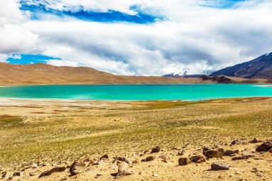
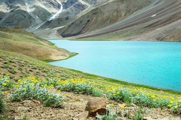
Chandratal Lake is located at an elevation of 4,300 meters in the lofty Himalayas and looks just as its name implies. Chandra translates to moon, while Taal means lake. However, the simple translation doesn't capture the essence when you arrive. The lake actually has a crescent shape. Its bright turquoise water can shift from sleek emerald green to dark blue, depending on how the sunlight hits it and the time of day. The mountains surrounding it form a natural amphitheater that enhances its otherworldly charm. Locals describe it as mystical. Visitors find it to be transcendent. Scientists view it as a delicate high-altitude wetland ecosystem that needs to be preserved. All these perspectives are valid. Chandratal is not only visually attractive. It lies at the meeting point of several Himalayan areas: officially in Lahaul Valley, spiritually linked to Spiti, and situated between Manali and Kaza. Getting there requires planning, physical fitness, and respect for altitude. The adventure is worth every bit of effort. To truly grasp Chandratal is to understand something significant about the Himalayas: breathtaking beauty thriving in truly harsh environments, delicate ecosystems that sustain life in unlikely locations, and the essential need to care for such extraordinary settings.
The most distinctive feature of Chandratal is its crescent shape. This is not by chance. The lake was formed in a glacial basin, shaped over thousands of years by the movement of ancient ice. The bowl-shaped depression created by the glaciers naturally curves like a crescent. The mountains made of scree around it and the shape of the bowl enhance the visual impact. When the moonlight shines on the water during full moon nights, it creates a magical scene. The appearance of the water changes throughout the day due to the minerals from glacial streams and the angles of sunlight. Early morning reveals softer blues. At noon, the water looks strikingly turquoise. As the afternoon progresses, it turns deep green. This ability to change colors gives the lake a feeling of being alive, as if it reacts to the sky rather than merely reflecting it. Hindu mythology tells that Lord Indra, the king of the gods, came down to bathe in Chandratal to cleanse himself of sins. The Mahabharata connects the lake to Yudhishthira, the eldest Pandava brother, who Indra is said to have taken to heaven from this very spot. Local legends talk about the Moon God, Chandra, and a divine nymph eternally meeting here. These mythological tales may not be historical truths. They are cultural meanings that have been given to the landscape because the landscape itself asks for significance.
Here are the Routes:
Route One: Through Manali (Famous but Longer)Begin at Manali, then head through the Atal Tunnel to reach Gramphu. From Gramphu, take NH505 northward toward Batal, which is about 80 kilometers away. The drive lasts around 4 to 5 hours along bumpy mountain paths. From Batal, there is a challenging 14-kilometer road leading to the parking area by Chandratal. A high-clearance 4x4 vehicle is necessary for this stretch. The path is rocky, sometimes inundated with glacial streams, and truly perilous. The total trip from Manali to the Batal parking area takes roughly 6 to 8 hours, depending on how the roads are.
Route Two: Through Kaza (Shorter but Just as Difficult)From Kaza, the primary town in Spiti, head north toward Losar. Climb up to Kunzum Pass, which reaches 4,590 meters. Right before you go down from Kunzum Pass, there’s a rough side road of 8 to 10 kilometers that goes toward Chandratal. This route is about 80 to 90 kilometers from Kaza and takes around 3 to 4 hours. While the road is somewhat better than the Batal route, it is still unpaved and tough.
The Final Hike: You can’t drive all the way to the lake. From the parking area, you need to walk 1.5 to 2 kilometers. This hike might seem easy at first. However, at 4,300 meters with thin air, it challenges how well you have adjusted. The trail goes through rocky areas and grassy fields. The lake reveals itself slowly as you approach, building excitement.
Chandratal is open for visits only from June to September. The best weather is usually from mid-June to August. July and August are the busiest times. By September, it gets cooler, and there might be early snow. October is quite risky. Winter months from November to May make travel impossible. Snow covers the roads with several meters of buildup. The lake completely freezes. During summer, daytime temperatures range from 5 to 15 degrees Celsius. Night temperatures can drop to between minus 5 and minus 10 degrees. Even in summer, you will need thick jackets and sleeping bags. In winter, temperatures may fall to minus 20 degrees or lower. This weather must be taken seriously.
This situation isn't a man-made rule; it’s a matter of geography. The roads become unusable. Snow can reach over 10 meters deep in winter. Trying to visit outside of the main season can be quite dangerous. The limited time for visiting creates a natural need for careful planning. At 4,300 meters with little light pollution, the night sky is truly breathtaking. The Milky Way can be seen clearly without special gear. You can do astrophotography without needing fancy equipment. Bring a strong headlamp and warm clothes for several hours of stargazing. The lake and the area surrounding it offer countless chances for photos. The light at sunrise and sunset changes the mountains into something almost unreal. Reflections in the lake create great photo compositions. Every visitor leaves with many good pictures.
The main attraction of the lake is in our mind. When you stand in front of its curved outline, with empty mountains around you, and hear the wind and quietness, something changes inside you. Many tourists spend a lot of time sitting in silence. This time is not wasted. It is part of the real experience. From the lake, you can take day hikes to Kunzum Pass, which is about 12 to 15 kilometers away and moderately challenging. At the pass, there is the Kunzum Mata Temple, which offers both a spiritual and physical challenge. You can also explore the glacial streams that flow into the lake or hike to higher meadows. The high-altitude environment supports wildflowers that bloom from June to August. If you are really lucky and patient, you might see Himalayan ibex or blue sheep on the far slopes. Although snow leopards live in the area, it is very uncommon to see them. Bird watchers might notice birds like the Ruddy Shelduck. Most people may not spot anything but still enjoy trying.
Chandratal Lake sits at the crossroads of land, stories, nature, and human strength. It is known as Moon Lake because of its moon-like shape, its ties to moon-related stories, and the truly magical feeling you get when standing there under the moonlight. Getting there takes careful planning, getting fit, and acknowledging the high altitude. Once you arrive, the experience changes your view of mountains, silence, and beauty. The crescent shape is not just by chance. The shifting colors of the water are not random. The cold air, the high altitude, and the utter stillness show a natural system that was perfectly balanced long before people came and will remain so after we are gone. To visit Chandratal in a responsible way means you must see your place in this larger system rather than expecting everything to cater to you.